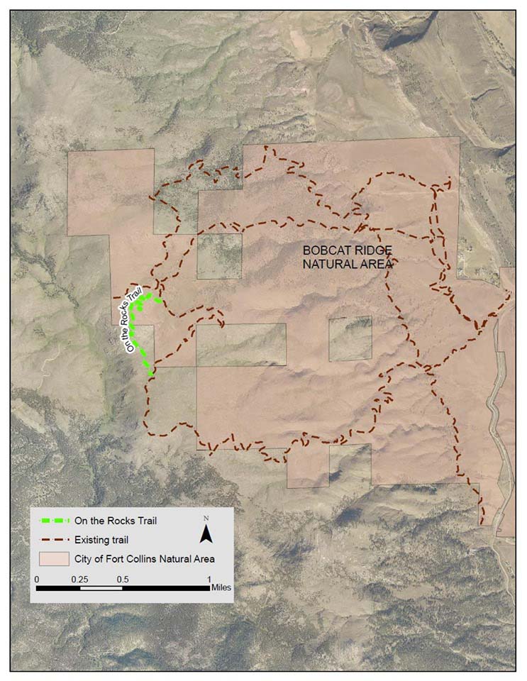
After over five years of hard work, with Steve Lacey leading the charge, On the Rocks Trail is now open at Bobcat Ridge. The one mile long, expert-level trail is roughly 3 miles from the trailhead on the Western edge of Bobcat Ridge Natural Area. The Southern half of the trail passes through the Roosevelt National Forest before returning to Ginny Trail. The trail starts out at 6900′, peaks at 6935′ and descends to 6624′. Derek Russell currently has the Strava KOM with a time of 15:19 and Marie Walsh has the QOM with a time of 21:11.
Strava segment: https://www.strava.com/segments/21240884
Via Fort Collins Natural Areas
Released on Sunday, July 21, 2019
https://www.fcgov.com/news/?id=7499
A new trail at Bobcat Ridge called “On the Rocks” opened earlier today.
On the Rocks provides one mile of scenic hiking and black diamond (expert) level mountain biking trail several miles into Bobcat Ridge.
Natural Areas staff co-created the trail with volunteers from Northern Colorado Grassroots, Otterbox, and Overland Mountain Bike Association.
Steve Lacey of Northern Colorado Grassroots said, “It’s been a long time coming but I think the On the Rocks trail will really showcase how volunteers and land agencies can work together to create a special trail that opens the possibilities of what trails can be, yet still adhere to the directives of our public spaces. The On the Rocks trail winds through some of the most unique landscape in Fort Collins which would not have been accessible if not for the On the Rocks trail.”
Todd Juhasz of Fort Collins Natural Areas said, “On the Rocks illustrates a collaborative relationship between Natural Areas and mountain bikers who share similar values: dedication to conservation and providing unique recreational opportunities.”
Mountain bikers and hikers are invited to enjoy the new On the Rocks trail, when Bobcat Ridge is open, daily from dawn to dusk. Bobcat Ridge is popular, the busiest times are weekends, 9 a.m. to 3 p.m. Avoid these times for a better chance at finding parking. If the parking lot is full, you must come back another time as there is no parking on the road. Find trail conditions and a parking lot webcam at https://www.fcgov.com/naturalareas/status.php
Via the On the Rocks Trail Facebook page
07/22/2019
https://www.facebook.com/ontherocksatbobcat
On The Rocks from the Beginning
As the saying goes…“Good things come to those who wait.” This couldn’t be truer for the completion of the “On the Rocks” trail.
After riding through Mahoney Park for the first time shortly after the natural area opened, the cries from the boulder field to the west could be heard begging for attention. The cries warranted a scouting trip through the area and it was clear a trail should be carved through the area to showcase the unique rock formations and terrain.
In early 2014 the trail proposal for On the Rocks was drafted and formally submitted the City Natural Areas Department. This trail proposal was met with some pretty luke warm feelings from the start, but persistence and will prevailed. Late in 2018 the trail was approved, following the completion of the Bobcat Ridge Management Plan Update, and it didn’t take long to start flagging On the Rocks.
In the beginning, scouting through the area for the perfect corridor was an arduous task due to the amount of deadfall from the previous forest fire. Lines of sight were hard to follow and it took many trips back and forth to pick a way through the different rock outcroppings while imagining what a trail user would experience from every spot. MTB’s were hauled up, under, through and used to test some of the proposed sections. Some sections just had to be kept as mental pictures until work could begin.
Hundreds of pin flags were placed to help the City Natural Areas trail crew see the potential route of the trail and it was agreed to start cutting through the deadfall. It took 4 -5 men and a few chain saws to cut through all the deadfall but in the end we could tell we had the beginnings of an epic trail.
With the deadfall cleared the shape of the trail could really be seen and the fun could really start. Defining sections, build strategy, ownership of sections, documentation and so forth. In the end three groups were to be tasked to complete up to 40 unique sections of the trail; The City Natural Area trail crew, OMBA and a core volunteer group. Natural Areas ensured each section of trail was classified, and given to the appropriate group based on the difficulty and type of work to be done.
Just when we thought we had all of our ducks in a row, a little fly jumped into the ointment. Since the trail crossed into USFS property they wanted to conduct their own impact study on the area before any trail work could continue possibly jeopardizing the entire project. Months went by without any updates from the USFS. Could this be the end of the line for the trail as it was planned? The Director of the City Natural Areas Department made some calls to the right people within the USFS and got the permit for the trail pushed through. We were back in business.
The real trail work began the later part of 2018. Since this project wasn’t really on the City trail crew’s project plan for 2018 most of the early work was completed by small groups of volunteers a couple days per month. One big challenge in recruiting volunteers to help was the fact that they were responsible to get up to the worksite on their own. Traveling up Ginny or the Power Line trails is no joke and then to work for a few hours and ride back down the Ginny trail takes putting some skin in the game…sometimes literally.
Weather in early 2019 kept work to a minimum to start, but that quickly ramped up with the City Natural Areas ability and added manpower. Sections of the trail were being completed on a regular basis and each section was constantly tested for usability while keeping its ability to challenge advanced users.
Although the trail was initially proposed by local residences of Fort Collins, the City Natural Areas trail crew took their pieces of the trail and really made it their own, and it shows with their attention to detail and craftsmanship. Hopefully visitors will take time to look at some of the sections and appreciate the time and effort it took to build these sections to make this trail possible. The expansive views, unique rock formations and other geological features of the area are also something to take time to hunt for and study as well.
At just over a mile long the trail isn’t the longest in the area but you’d be hard pressed to find a trail that kept you smiling for that long if your ability suits it and you don’t get caught daydreaming and lose focus of where you are on the trail.
On the Rocks is officially open to enjoy!